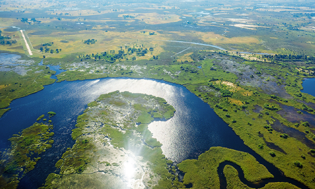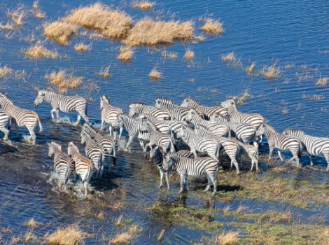
Botswana’s enduring appeal is rooted in the striking landscapes that provide its endless horizons and nourish expansive wildlife populations – the unique features of the Okavango and Makgadikgadi in particular. This land has endured a simple but fascinating geological history over many million years, which has delivered to us the amazing country that we have today. Shaped by water, with some of the most intense concentrations of wildlife and the most idiosyncratic landscapes on the planet, Botswana leaves nothing to compromise.
Botswana’s vast horizons allow the imagination space to roam. And nowhere feels more spacious than Nxai Pan, on the eastern fringe of the Kalahari. During the parched dry season, when dust devils chase across desolate salt flats, nowhere feels emptier. But with the rains come new life. The skies boil and darken, the land turns green and the empty stage is braced for the thunder of hooves. The great herds are on their way.
It is now widely accepted that the continents that populate our planet are in constant motion, slowly drifting across its surface. Some 300 million years ago Africa was near the southern pole, part of Gondwanaland, and glacial conditions prevailed. As it moved north and warmed, the ice cover and glaciers melted to form swamps, lagoons and rivers and the exotic vegetation of those times accumulated to form our massive coal deposits of today. Gradual drying over millions of years, and slow but continual movement north, turned swamps to mudstone to shale and in the depressed centre of the sub-continent vast quantities of sand collected, forming over time great depths of sandstone.
Around 180 million years ago Gondwana began to break up and massive sheets of basalt covered the land. Remains of this outpouring can be seen in South Africa’s magnificent Drakensberg Mountains and Victoria Falls, the rapids at Commissioner Kop in Kazungula and, further upstream along the Zambezi, the wonderful horseshoe Ngonye Falls at Sioma in western Zambia.
At first, the major rivers as they are today did not follow their present courses. We know that the Upper Zambezi, the Kwando, Okavango and Cubango combined to flow across northern Botswana and, via what is now the Limpopo, emptied into the Indian Ocean. Tens of millions of years ago, an uplift of the land surface along a line running northeast-southwest – roughly from Harare through eastern Botswana and curving into the central Kalahari, like a ripple in a stretched blanket – interrupted the passage of this former river and, acting like a dam wall, caused it to back-fill over most of northern Botswana, creating a massive lake.
Over succeeding millennia the rivers, responding to regional warping of the land surface and river capture, were sequentially removed from the inflow so that, as each was excised from the system, a series of relatively rapid drops in the lake level can be discerned. Though quite clear on satellite imagery, the oldest shoreline is difficult to detect and, indeed, the 995 level was only recently discovered. However, the 945 level is very clear and easy to see. Today you can stand at a signposted stop 104km from Maun on the road to Nata, and see the ridge curving away to the north and south, a marker in this cluttered thorn-veld of the edge of a former sea. The basalt dyke across the Chobe river near Mowana Lodge in Kazungula held the lake at 936 metres before it was breached, allowing the lake to fall from that level to 920 metres.
Eventually, with the capture of the Upper Zambezi by what is now the river passing over Victoria Falls and the extension of the East African Rift Valley that stopped the Okavango in its tracks, the great lake was no more. We were left with the amazing salt pans we call collectively Makgadikgadi, but which actually consists of two major pans, Ntwetwe in the west and Sowa in the east.
The pans are a stunning spectacle: the morning and evening light quite phenomenal. It is strange that such a place can be so beautiful for it is quite featureless. The surface is flat and hard and relentless. You will see no stones, no leaves, no grass.
On a grey day it can be hard to distinguish land and sky and yet, from the shores of the very occasional rocky island, for example, the openness, the vastness, the astounding silence and the unlimited sky are breathtaking. There are few places in the world where, on a moonless night, you can pluck so many stars from the sky.
Creeping down the length of Africa, a rift valley that saw its birth in the Dead Sea has followed a line through East Africa, along the Luangwa and up the course of the Zambezi to stretch itself via a pattern of faults to create what we call today the Okavango Delta. A trough, some 300 metres deep, now filled with sand, lies beneath that swirling mosaic of island and lagoon – the sun-sparkled jewel of Botswana.
The Okavango is the only significant surface water in the whole country. We are bounded in the east by the Limpopo and the north-west by the Okavango and the Chobe, all rivers that played a major part in the creation of the landscape we see today and all much less than they once were. But in their passing, they have bequeathed to us the extraordinary Makgadikgadi and Okavango and the vast, once lake-bed that today supports Chobe and Nxai Pan National Parks and nurtures Botswana’s remarkable herds of game.
Source: This feature first appeared in edition 87 of Travel Africa magazine. To buy this issue, please click here, or to subscribe and receive future printed copies of the magazine, please click here.
Article by Mike Main – http://travelafricamag.com/full-immersion/?fbclid=IwAR0pcKreHDwptfUse9sXkoDElE948c_RtUBastd6THzUPmUJd3KAqrIU6hE


